 Carolina Bays Parkway Extension
Carolina Bays Parkway Extension
This site is designed to receive comments
on Corridor Concepts being presented.
For additional information on this project,
please visit the NCDOT website:
https://www.ncdot.gov/projects/carolina-bays-parkway/
PROJECT DESCRIPTION
The NC Department of Transportation and the SC Department of Transportation plan to extend Carolina Bays Parkway (S.C. 31) from S.C. 9 in Horry County, SC, across the North Carolina state line to U.S. 17 in Brunswick County. The project is expected to involve the construction of a multi-lane expressway and may involve both existing roadways and areas on new location.
SCDOT State Transportation Improvement Program (STIP) Project P029554 would extend Carolina Bays Parkway from its current terminus at S.C. 9 in Horry County to the North Carolina state line. NCDOT STIP Project R-5876 would extend Carolina Bays Parkway from the state line to U.S. 17 Shallotte Bypass in Brunswick County. Carolina Bays Parkway Extension is anticipated to involve the construction of a multilane, full control of access freeway, with part on new location. Full control of access means that access to Carolina Bays Parkway will only be provided via ramps and interchanges. Bridges will be installed at some cross streets and no driveway connections will be allowed.
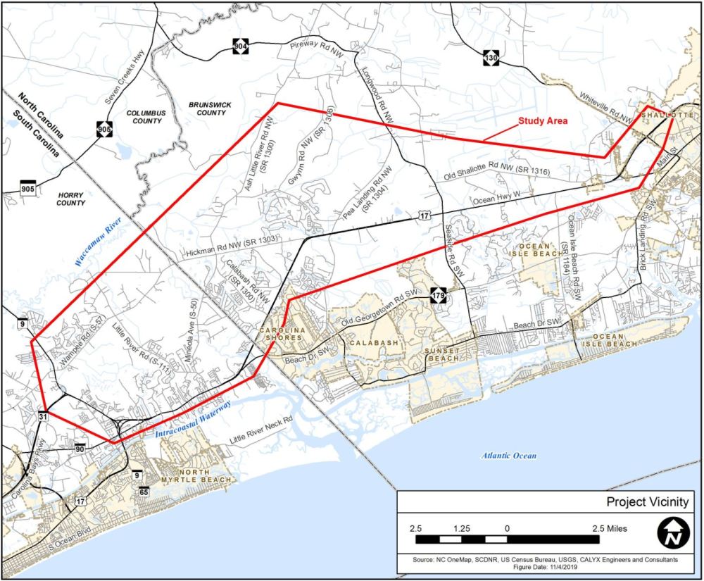
Carolina Bays Parkway Extension Study Area
The Carolina Bays Parkway Extension project area is largely comprised of unincorporated areas in Horry and Brunswick counties, but also includes portions of some coastal towns and communities located on the inland side of the Intracoastal Waterway.
A study area is a geographical area in which information on human and natural environmental features are gathered during the preliminary planning phase. The Carolina Bays Parkway Extension study area boundary was established with consideration given to the ability to develop a full range of alternatives while also minimizing potential impacts to important environmental features. The project study area is approximately 19 miles long, with approximately five miles located in South Carolina and 14 miles located in North Carolina.
The existing primary road network includes U.S. 17 and various North Carolina and South Carolina state highway and secondary routes. There are no interstate facilities in the project area and access along existing routes is largely uncontrolled. Outlined in red in the map below, the study area is much larger than the actual amount of land that would be directly impacted by the project and is subject to change as more information about the project is collected.
PUBLIC MEETING SCHEDULE
NCDOT and SCDOT, in coordination with the Federal Highway Administration (FHWA),held two Public Information Meetings on the proposed extension of Carolina Bays Parkway (S.C. 31).
SUNSET BEACHDecember 3, 2019 4:00 - 7:00 p.m. Sea Trail Convention Center 75A Clubhouse Road Sunset Beach, NC 28468 | LITTLE RIVERDecember 4, 2019 4:00 - 7:00 p.m. VFW Post 10804 111 State Hwy 57 North Little River, SC 27566 |
Note: Comments may be made on this site or emailed to: carolina-bays-extension@publicinput.com. Information provided, including name and address, will be published and is subject to disclosure under the Freedom of Information Act.
Persons who do not speak English, or have a limited ability to read, speak or understand English may receive interpretive services upon request prior to any meeting by calling 1-800-481-6494 (NCDOT) or 803-737-1395 (SCDOT).
Aquellas personas que no hablan inglés, o Tienen limitaciones para leer, hablar o entender inglés, podrían recibir servicios de interpretación si los solicitan antes de la reunión llamando 1-800-481-6494 (NCDOT) o 803-737-1395 (SCDOT).
CORRIDOR CONCEPTS
Nine Corridor Concepts have been developed for the proposed project. The nine Corridor Concepts are shown on the aerial photograph image below. Corridor concepts may be viewed individually by clicking on the corridor concept map links below.
Each of the nine Corridor Concepts begin at the existing Carolina Bays Parkway/S.C. 9 interchange in South Carolina and end at the U.S. 17 Shallotte Bypass in North Carolina. The location of the tie-in to existing U.S. 17 varies by corridor concept; however, all concepts would use existing U.S. 17 for approximately 6.3 miles between N.C. 904 (Longwood Road/Seaside Road) and N.C. 130 in Brunswick County. Three existing intersections are proposed for conversion to interchanges along this section of U.S. 17, including N.C. 904, Ocean Isle Beach Road, and U.S. 17 Business (Main Street).
The nine Corridor Concepts were developed to minimize impacts to natural and human environment features such as homes, businesses, wetlands, and streams. The Corridor Concepts shown are much wider than the area needed for a future road. The study corridors shown are generally 1,000 feet wide, but the recommended right-of-way width will be much narrower, in general approximately 400 feet. The 1,000-foot width of the study corridors was chosen to provide opportunities to further minimize impacts to homes, businesses, and natural resources as the project continues to develop.
The Community Characteristics Report for the project study area can be viewed here:
Carolina Bays Parkway Extension Community Characteristics Report
By clicking on the icon (
 ) on the top of each map set below,
you will have the option of turning on/off individual alternatives for ease of viewing.
(Clicking on the icon a second time will minimize the selection screen)
Corridor Concepts 1 Through 5
Corridor Concepts 6 Through 9
CORRIDOR CONCEPT MAPS
These maps were displayed at the December 3 and 4 public meetings: | |
| Corridor Concept 9 (Dark Green) | |
PURPOSE AND NEED
The primary purpose of the project is to improve the transportation network in the study area by enhancing mobility and connectivity for traffic moving in and through the project area.
Many intersections and roadway segments in the study area are expected to either approach or exceed the roadway capacity limits in 2040. In addition, the population within Horry and Brunswick counties has steadily increased, and is expected to continue to increase, along with the number of tourists to the area. Growth in population, tourism, and supporting services has resulted in an increase in mixed-purpose traffic on area roads.
Potential additional benefits of the proposed project may include:
- The proposed project offers the potential to reduce the number and severity of vehicle crashes by providing an alternate route to travelers. Separating through traffic from the local traffic that is using the existing roadways to access schools, shopping and services, and residential areas will likely enhance safety.
- By providing additional capacity and improving mobility in the project area, the proposed project offers the potential to support more efficient clearance times during emergency evacuations.
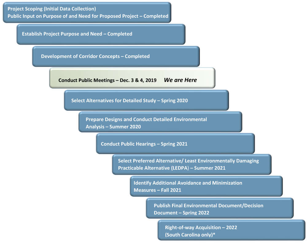
What are the Steps in the Project Planning Process?
The planning process can be divided into the steps shown below. Public involvement is an important component of the planning process and opportunities, both formal and informal, will be provided throughout the process so citizens can stay informed and provide input.
Carolina Bays Parkway Extension Major Planning Steps and Milestones
*Please see below for funding information.
COST ESTIMATE
| Jurisdiction | Estimated Cost* |
| North Carolina | $ 367 million |
| South Carolina | $ 185 million |
| Total Cost | $ 552 million |
* Estimated costs subject to change
The SCDOT 2017-2022 State Transportation Improvement Program includes funding utilizing Horry County RIDE III Sales Tax Funding for the purchase of property for the extension of Carolina Bays Parkway from S.C. 9 to the North Carolina state line beginning in 2022.

The NCDOT 2019-2029 State Transportation Improvement Program includes funding for planning and environmental studies only.
The project is currently not funded for right-of-way acquisition or construction.
Comments/Questions
Please submit your comments on this website or by email at (carolina-bays-pkwy@publicinput.com).
Comments may also be provided via U.S. Mail to one of the Project contacts listed below, or at any project meeting.
All comments received carry equal weight, regardless of submission method.
All public comments will be reviewed and suggestions/recommendations will be
incorporated where feasible throughout the process.
Note: Information provided, including name and address, will be published and is subject
to disclosure under the Freedom of Information Act.
PROJECT CONTACTS
| Ms. Krista Kimmel, P.E. | Ms. Leah Quattlebaum, P.E. | Ms. Liz Kovasckitz, AICP |
| Project Manager | Pee Dee Regional Production Engineer | Planning Program Manager |
| N.C. Department of Transportation | S.C. Department of Transportation | CALYX, an NV5 Company |
| 5501 Barbados Boulevard | PO Box 191 | 6750 Tryon Road |
| Castle Hayne, NC 28429 | Columbia, SC 29202 | Cary, NC 27158 |
| (910) 341-2000 | (803) 737-1751 | (919) 858-1808 |
| khkimmel@ncdot.gov | QuattlebLB@scdot.org | liz.kovasckitz@NV5.com |
Toll-free project information line: 1-866-841-4420 (8 a.m. - 5 p.m. weekdays)
RESOURCES FOR PROPERTY OWNERS
Although the N.C. Department of Transportation works to minimize the number of homes and businesses displaced by a road project, it is inevitable, in many cases, that a certain amount of private property is needed. The following information explains right-of-way acquisition and answers questions about the process.
Relocation Assistance Brochure Asistencia para Reubicación
Right-of-Way Acquisition Process Brochure Folleto del Proceso de Adquisición de Bienes Raíces
Right-of-Way Frequently Asked Questions