 McDowell Creek Greenway
McDowell Creek Greenway
Welcome to the McDowell Creek Greenway public input webpage. The McDowell Creek, Torrence Creek & Huntersville Downtown Greenways Network is currently 6.58 miles of main trail, 2.07 miles of access trails and 2.5 miles of urban trails. This network of greenways connect the Town of Cornelius to the Town of Huntersville and offers adjacent neighborhoods connections to great amenities such as the Westmoreland Park, Westmoreland Athletic Complex, Robbins Park, Jetton Park, Holbrook Park, Rosedale Nature Park, significant retail such as Birkdale Village and to nearby schools. The funded McDowell Creek Greenway projects will connect existing McDowell Creek Greenway (at Sam Furr Road) to existing Torrence Creek Greenway (at Gilead Road), and extend the greenway network to Beatties Ford Road to the west, and to Catawaba Avenue to the north. These McDowell Creek Greenway projects will add 5.41 miles of main trail, 4.19 miles of access trails and 2.89 miles of urban trails to the existing network.
The funded greenway trail projects have been divided into multiple segments for implementation due to funding, partnerships and land acquisition:
Segment 1a extends from existing Torrence Creek Greenway to Gilead Road. (Project construction is complete)
Segment 1b extends from Gilead Road to Chilgove Lane. (Project construction is complete)
Segment 2 extends from Chilgrove Lane to Highway 73. (Notice to Proceed with Construction - September 2025)
Segment 3 extends the Highway 73 Crossing via pedestrian bridge to connect to existing McDowell Creek Greenway. (Project in design by NCDOT)
Segment 4a: Restroom at Gilead Road Parking Trailhead (Project in construction)
Segment 4b: extends from Gilead Road to Beatties Ford Road (Project in design and land acquisition)
Segment 5: extends from JV Washam (Westmoreland Rd.) to Smithville (E. Catawba Ave). (Project in design and land acquisition)
Learn more about existing Park and Recreation locations and amenities: https://gis.mecklenburgcountync.gov/MecklenburgCountyParkExplorer/
Below you will find project updates and timelines, meeting dates, key contact information, and other important information about the McDowell Creek Greenway projects. You may also give feedback and ask questions about the greenway. We encourage you to provide your input and stay connected!
Segment 1
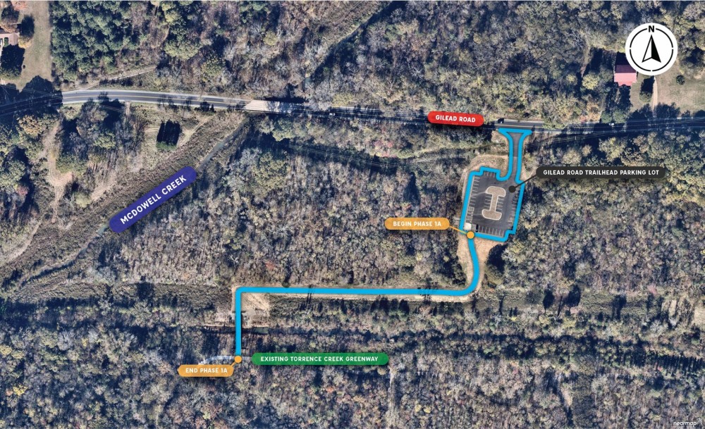
Segment 1a: McDowell Creek Greenway, Torrence Creek Greenway to Gilead Road (CONSTRUCTION COMPLETE)
- .15 miles of main trail, .3 miles of access trail, 1 bridge, minor upgrades to Torrence Creek Greenway and a parking trailhead at Gilead Road.

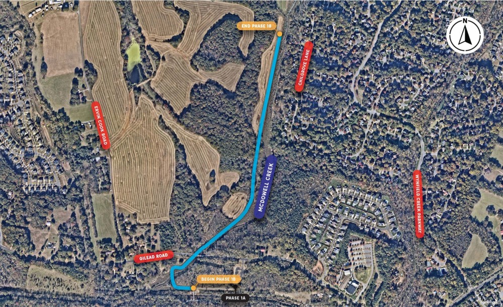
SEGMENT 1B: McDowell Creek Greenway, Gilead Road to Chilgrove Lane (CONSTRUCTION COMPLETE)
- .68 miles of main trail, .28 miles of connecting trails, 1 bridge, a crossing under Gilead Road and an overlook.

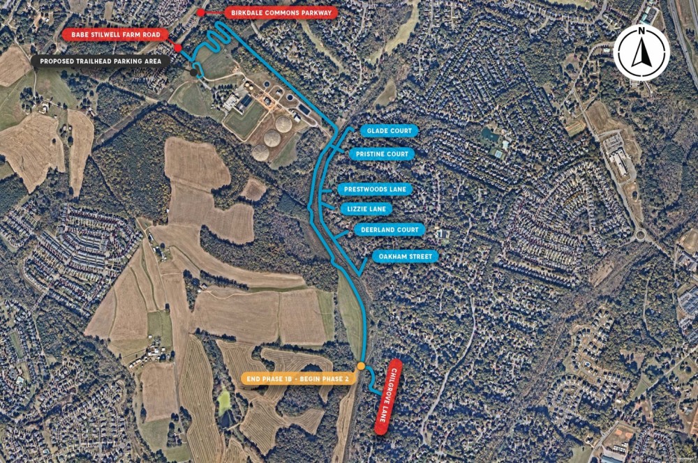
Segment 2: McDowell Creek Greenway, Chilgrove Lane to Highway 73 (IN CONSTRUCTION)
- .75 miles of main trail, .46 miles of access trails, paving of dirtway, 2 bridges and a parking trailhead
- Funded in partnership with the North Carolina Department of Transportation.
- Conservation easements have been established east of the creek where some natural surface trails exist. For additional information, please go to the documents section below.
- Construction is underway. The contractor will determine when existing natural surface trails will be closed for construction. Signs for closure will be posted at trail entrances for the duration of the construction.
- Clearing has been completed and grading operations have begun.
Segment 3: McDowell Creek Greenway, Highway 73 Crossing (IN DESIGN)
- Crossing of NC73 that will connect existing McDowell Creek Greenway with future greenway (phase 2) currently in construction.
- To be developed in partnership with NCDOT's Project U-5765-NC73 Widening from Catawba Ave. to Northcross Dr.
- Design by NCDOT is ongoing for a pedestrian bridge over NC73.
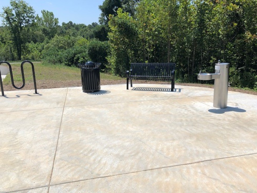
Segment 4a: McDowell Creek Greenway, Restroom at Gilead Road Trailhead (IN CONSTRUCTION)
- Restroom Building
- Funded in partnership with the Town of Huntersville.


Segment 4: McDowell Creek Greenway, Gilead Road to Beatties Ford Road (IN DESIGN)
- 2.08 miles of main trail, 1.13 miles of access trails, 2 bridges and a parking trailhead.
- Funded in partnership with the Town of Huntersville.
- Project is in design and real estate acquisition. Once these components are further along, there will be a public information session.

Segment 5: McDowell Creek Greenway, JV Washam (Westmoreland Rd.) to Smithville (E. Catawba Ave.) (IN DESIGN)
- 1.6 miles of main and access trails, 4 bridges and a .7 mile multi-use path along Westmoreland Rd. connecting to existing greenway.
- Funded in partnership with the Town of Cornelius.
- Project is in planning and real estate acquisition.

Project Schedule
Survey Questions for Segments 1 & 2:
Greenway Master Plan:

Additional questions?
Contact:
Gwen Cook, Planner
Gwen.Cook@MecklenburgCountyNC.gov or 980-314-1036
-OR-
Joyce Figueroa, Planner
Joyce.Figueroa@MecklenburgCountyNC.gov or 980-314-1055
Segment 2: McDowell Creek Greenway, Chilgrove Lane to Highway 73 (IN CONSTRUCTION)
- .75 miles of main trail, .46 miles of access trails, paving of dirtway, 2 bridges and a parking trailhead
- Funded in partnership with the North Carolina Department of Transportation.
- Conservation easements have been established east of the creek where some natural surface trails exist. For additional information, please go to the documents section below.
- Bidding Complete; Construction start projected for September 2025. The contractor will determine when existing natural surface trails will be closed for construction. Signs for closure will be posted at trail entrances for the duration of the construction.
Segment 1a: McDowell Creek Greenway, Torrence Creek Greenway to Gilead Road (CONSTRUCTION COMPLETE)
- .15 miles of main trail, .3 miles of access trail, 1 bridge, minor upgrades to Torrence Creek Greenway and a parking trailhead at Gilead Road.