Port of Fort Pierce Master Plan - Final Plan
Port of Fort Pierce Master Plan - Final Plan

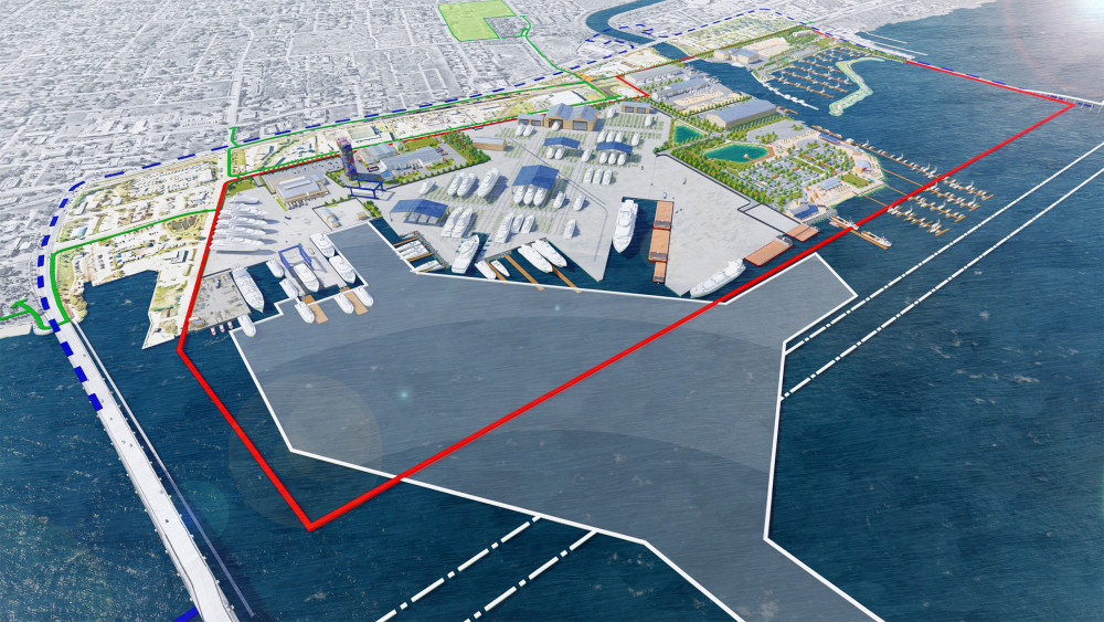
Perspective rendering - Artistic representation of proposed project features.
SUMMARY
This Master Plan for the Port of Fort Pierce establishes a roadmap to achieve a truly diverse working waterfront. The Plan embraces new industries and opportunities aligned with the goals of expanding economic and social benefit to the citizens and businesses found in St. Lucie County and along the Treasure Coast.
The Port has been a fixture of the Fort Pierce community since the 1920s. Establishment of the Fort Pierce Inlet and a small but functional set of docks and transit sheds provided an important export point for Treasure Coast agricultural products. it also offered a source of employment for residents of the City of Fort Pierce. As the century marched forward, the work of the Port remained meaningful but modest when contrasted with the establishment and growth of other East Coast seaports.
In May 2020, St. Lucie County engaged the consulting team of Atkins and Moffatt & Nichol to explore how best the Port of Fort Pierce should author its next chapter as a unique economic and community asset in the region and the State of Florida. Every five years, Florida seaports are required to update their long-range plan to identify and guide port investments to ensure alignment with local comprehensive planning and other regional initiatives. This update meets State requirements and builds on the previous work conducted in 2015.
Importantly, the Port heads into the next decade with the recent successful purchase of the 12-acre Indian River Terminal and selection of Derecktor Shipyards Inc. to invest in and operate a megayacht maintenance, refit, and overhaul facility. This Plan update looks to capitalize on this momentum, exploring ways in which this new anchor can be catalytic for other Port investment.
PLAN-MAKING
A common theme heard throughout the 2020 plan-making process was the Port and its lands, harbor, and channel are an untapped resource. Accompanying this sentiment, however, was often a similar caution that harnessing this resource should be done carefully and ensure protection of community quality of life and the ecology and recreational attributes of Fort Pierce Inlet. This Plan update seeks to strike this balance.
A variety of options for public and private land to evolve into a diverse working waterfront were explored. Options were prepared, refined and established through active dialouge with the County, City, property owners, agencies, and the public. While this was made more challenging due to to the COVID-19 Pandemic, conversations about the future of the Port were robust and substantive, utilizing all manner of virutal meetings, online surveys, conference calls, and (limited) in-person meetings.
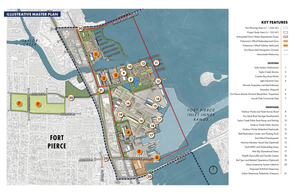
Perspective rendering - Artistic representation of proposed project features.
THE 2020 PORT OF FORT PIERCE MASTER PLAN
The planning result is a multi-faceted vision for the Port that calls for:
- Creation of the Treasure Coast's premier center for yacht, shipbuilding, and related marine repair, overhaul, and maintenance facilities;
- Investment in County owned Harbour Pointe Park to emerge as a public marina, boat ramp, and upgraded park; and,
- Advancement of a new wharf and surrounding uplands dedicated to the support of small import/export marine dependent businesses.
Implementation of the Master Plan will take 10- to 20-years. Success relies on favorable market conditions, incremental investment by the public and private sector, and sustained community alignment and goodwill. Achievement of the aims and projects contained in the Master Plan are worthwhile, and will result in an active, working waterfront that serves as another important engine driving economic and social progress for the County and region.
WHAT COMES NEXT?
The following next steps are underway:
- The Final Draft Plan is available for public review. Your can access a PDF version from the downloads box below. A version of the Plan is currently undergoing conversion to meet requirements to make it fully accessible to everyone.
- A special meeting of the St. Lucie County Board of Commissioners to consider the Plan will be held on November 12, 2020 to begin at 1:00 PM or soon thereafter within the Board of County Commissioners Chambers. Details to follow and will be emailed to all on the website’s subscriber list. Press release and public notice will also be made.
PLANNING PROCESS REWIND
If you were not able to participate, explore results of Public Engagement Session 1 and 2. Each virtual meeting session was recorded and available for viewing at the links below. The base content and presentation was the same for each meeting; audience comments varied. An archive of all previous planning presentations, posters, survey results, and materials is also available below.
Public Engagement Session One (Virtual Meetings 1, 2 and 3 offer the same presentation):
Virtual Meeting 1 - July 1 at 3:00 PM - https://publicinput.com/A782
Virtual Meeting 2 - July 1 at 6:30 PM - https://publicinput.com/X623
Virtual Meeting 3 - July 2 at 9:00 AM - https://publicinput.com/J560
Public Engagement Session Two (Virtual Meetings 4, 5 and 6 offer the same presentation)
Virtual Meeting 4 - July 29 at 3:00 PM - https://publicinput.com/P315
Virtual Meeting 5 - July 29 at 6:30 PM - https://publicinput.com/S370
Virtual Meeting 6 - July 31 at 9:00 AM - https://publicinput.com/P722
Have questions or comments you would like addressed by St. Lucie County? Please contact Project Manager Kori Benton (bentonk@stlucieco.org) at any time.
AVAILABLE PRESENTATIONS AND DOWNLOADS
Please find below links to master plan posters, presentations, and survey results. We will continue to add to this archive as materials are prepared, refined, and released.
Documents
OVERALL PLAN MAKING CALENDAR
