 U-6202: Gordon Road from I-40 to U.S. 17 (Market St.)
U-6202: Gordon Road from I-40 to U.S. 17 (Market St.)
The N.C. Department of Transportation proposes to widen Gordon Road from I-40 to U.S. 17 (Market Street) in New Hanover County.
The purpose of the project is to improve capacity and reduce congestion along Gordon Road and is intended to aid in managing the growth that the Wilmington area has been experiencing.
Interactive Study Area Map
Virtual Public Meeting
The virtual public meeting was held Tuesday, Dec. 7. A recording of the meeting can be found below.
Project Video
Visualization Video
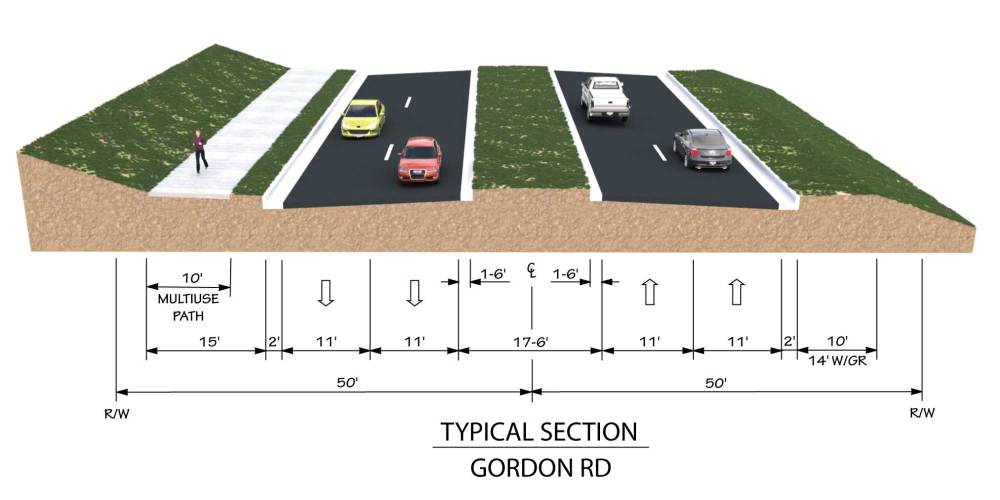
Proposed Design
This 2.5-mile long project will widen Gordon Road to a four-lane divided roadway with a 17.5-foot raised median.
The project would install what are known as reduced conflict intersections (RCI). The most common type of reduced conflict intersection design eliminates left turns from side roads onto busy main roads.
Raised medians direct traffic from the side road into turning right. When there is a safe opening in traffic, drivers enter the flow of traffic on the main route. To go the other direction, or cross the highway, they pull into a dedicated lane – typically less than 1,000 feet away – and make a U-turn. There might be a traffic signal at this location.
The proposed typical section will include:
11-foot travel lanes with curb and gutter
10-foot multi-use path,separated from the roadway by a grass area, on the north side
Project Maps
Map 1: Brierwood Road to Lake Emerald Drive
Map 2: Lake Emerald Drive to Gordon Acres Drive
Map 3: Gordon Acres Drive to U.S. 17 Business (Market Street)
A video explaining how to read a public hearing or meeting map can be viewed below. The video contains information on colors used and symbology.
Project Impacts
Potential Impacts to Human and Natural Resources* |
|
|---|---|
Residential Relocations | 14 |
Business Relocations | 0 |
Archeological Resources | 0 |
School/Place of Worship/Park Relocations | 0 |
Streams (linear feet) | 473 |
Stream Crossings | 5 |
Wetlands (acres) | 0 |
100 year floodplain (acres) | 0.2 |
500 year floodplain (acres) | 0.3 |
Noise Impacts | TBD |
* Potential impacts are preliminary and subject to change
Project Schedule
Milestone | Date* |
|---|---|
Virtual Public Meeting | December 2021 |
Environmental Document Completion | Spring 2022 |
Right-of-Way | Summer 2022 |
Construction | Fall 2024 |
* Future dates are preliminary and subject to change
Project Funding
| Estimated Amount* |
|---|---|
Project Development & Design | $2,500,000 |
Right-of-Way | $14,000,000 |
Utility Relocation | $4,500,000 |
Construction | $28,000,000 |
Total Costs | $49,000,000 |
* Costs are preliminary and subject to change
Public Input
Due to Covid-19, NCDOT has suspended in-person meetings until further notice.
NCDOT accepts comments throughout all phases of project development.
The public is encouraged to leave comments using this website, email, or phone number.
Project email: GordonRoad-Widening@publicinput.com
Project phone: 984-205-6615 enter code 4244
Project Contact
Brian Harding, P.E.
NCDOT Division 3 Design Engineer
5501 Barbados Boulevard
Castle Hayne, NC 28429
GordonRoad-Widening@publicinput.com
984-205-6615 enter code 4244
The National Cooperative Highway Research Program has developed a tool to help us measure the effectiveness of our public involvement activities.
We are interested in your perceptions of the public involvement activities, events, and processes that have occurred up to this point in time. Your answers are completely anonymous.
Your feedback is very important to us. We will use the data collected from this assessment to evaluate the public involvement for this project so that we can best meet the needs of those potentially affected by the project.
RESOURCES FOR PROPERTY OWNERS
Although the N.C. Department of Transportation works to minimize the number of homes and businesses displaced by a road project, it is inevitable, in many cases, that a certain amount of private property is needed. The following information explains right of way acquisition and answers questions about the process.
Right-of-Way Brochure Single Page Layout Folleto del Proceso de Adquisición de Bienes Raíces
Right-of-Way Frequently Asked Questions
Right of way Acquisition Process Videos