Vulnerability and Resilience: Hillsborough County’s Community Vulnerability Assessment, Adaptation Plan, and Local Mitigation Strategy
Vulnerability and Resilience: Hillsborough County’s Community Vulnerability Assessment, Adaptation Plan, and Local Mitigation Strategy
Welcome to the virtual public engagement for Hillsborough County’s Vulnerability Assessment, Adaptation Plan, and Local Mitigation Strategy. Your participation will help provide insight into areas that are most at risk of flooding, which will help direct mitigation efforts to keep the community safe and assure a speedy recovery in times of crisis. The virtual public engagement will be open from Tuesday, April 16, 2024.
Overview
What does this mean to you?
Your participation will help provide insight into areas that are most at risk of flooding and other hazards – and that will help direct mitigation efforts to keep our community safe and assure a speedy recovery in times of crisis.
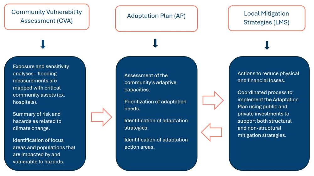
The storm surge threat, amplified by climate change and sea level rise, requires constant awareness of the dangers and risks to human health and infrastructure in coastal communities. Hillsborough County is engaged in a planning process to update the Community Vulnerability Assessment (CVA) that was initially conducted in 2020.
A Vulnerability Assessment helps the community measure the potential impacts of flooding and sea level rise. It identifies structures, infrastructure, people, and natural resources that may be affected. The CVA will be used to inform a comprehensive Adaptation Plan.
The Adaptation Plan is a guide to identify areas at risk and to identify adaptative strategies that could be implemented.
Those two initiatives will inform the Local Mitigation Strategy (LMS), which reduces the risks associated with natural and human-caused hazards. The cities of Tampa, Temple Terrace, and Plant City also participate in the LMS planning process. All jurisdictions remain eligible for grants from FEMA's Hazard Mitigation Assistance by maintaining an LMS.
The Project
What is a 100-year Plan?
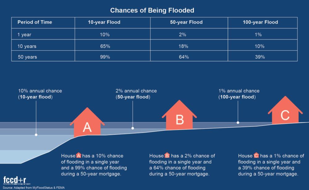
The phrase “100-year flood” is often mistakenly thought to mean a flood that occurs every 100 years. However, the phrase really means that there is a 1-in-100 chance of flooding in any given year. Floods are classified according to their frequency and depth. For example: A 100-year flood, although less frequent than a 10-year flood, is deeper and far more destructive.
MYTH: Your chance of experiencing a flood is once every 100 years.
TRUTH: A property in a 100-year flood zone has a 1% chance of flooding in any given year, which means it can also flood more than once within a 100-year period, and more than once in the same year.
MYTH: People may believe that if their property has not flooded within the past 100 years, they can’t possibly be in a 100-year flood zone.
TRUTH: Statistical averages based on past precipitation records give us information, but not guarantees. Nature can be unpredictable, so we adhere to crucial statistics and best practices.
Local Mitigation Strategy
What is hazard mitigation?
Hazard mitigation is any sustained action taken to reduce or eliminate long-term risk to life and property from hazards, such as flooding, hurricanes, or hazardous spills.
Disasters can cause loss of life and damage to buildings and infrastructure and have long-lasting impacts on a community’s economic, social, and environmental well-being. To prevent this, mitigation actions are taken, such as public education and outreach programs, elevating buildings above potential floodwaters, or strengthening building codes to ensure new buildings can withstand hurricane-force winds.
Hillsborough County is striving to become a disaster-resilient community, so proactive mitigation planning is an important component of overall development planning.
To avoid being stuck in a cycle of continually rebuilding and recovering after disasters, hazard mitigation encourages building in a way that prevents the damage from occurring in the first place. Hillsborough County focuses on hazard mitigation planning to reduce risk and create a safer, more disaster-resilient community.
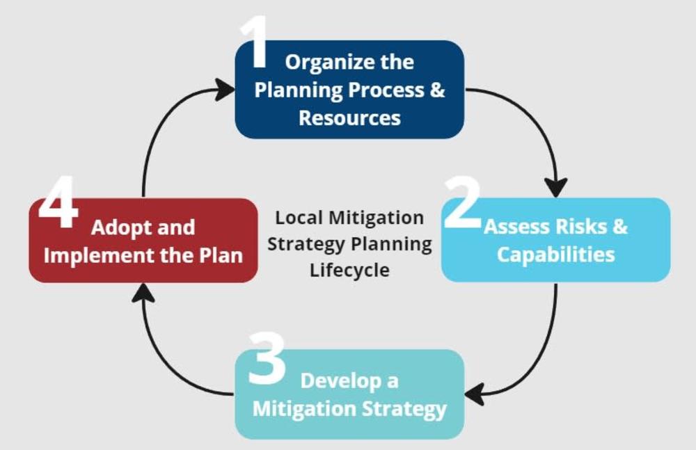
Our Local Mitigation Strategy
The Local Mitigation Strategy is a comprehensive document that not only identifies potential hazards but also assesses the areas vulnerable to the hazards that may strike Hillsborough County and the cities of Tampa, Temple Terrace, and Plant City. It goes further to outline possible actions that can effectively mitigate potential damage in the future. This strategy, which includes the county's Floodplain Management Plan and the county's Community Wildfire Protection Plan, is our commitment to your safety and security.
Planning Process Outcomes
Reduce risk to people, property, and the critical infrastructure.
Increase public awareness and education about the plan and planning process.
Maintain grant eligibility for participating jurisdictions.
Update the plan in accordance with Community Rating System (CRS) requirements.
Maintain compliance with state and federal legislative requirements for local hazard mitigation plans.
Complete an update of information in the plan to demonstrate progress and reflect current conditions.
Resources
Public Participation
We want your input!
Public participation is critical for a successful planning process. Residents know our community better than anyone, so we want to hear from you! Local knowledge ensures we create plans that understand what matters most and reflects that in proposed actions.
Public Engagement Timeline

Project Meetings
Meetings
Meetings will be held throughout the planning process for the VA, Adaptation Plan, and LMS.
VA Public Outreach Meeting #1:
The Florida Center for Community Design + Research (FCCD+R), in partnership with Hillsborough County, is updating the Community Vulnerability Assessment - to help the community measure and prepare for the potential impacts from flooding and sea level rise. We will be asking you to verify/identify structures, infrastructure, populations, and natural resources that may be affected.
Date: Tuesday, April 16, 2024
Time: 6-7:30 p.m.
Location: Town & Country Regional Public Library
7606 Paula Dr, Suite 120
Tampa, FL 33615
In order to help people participate, the meeting will be broadcast online via Teams here: Link to live meeting.
The meeting will be available for replay on this website. Watch here.
Map
The interactive map below is designed to gather input from community memebers about their lived experiences throughout the County.
Survey
LMS Public Survey - Opens Spring 2024
This survey is for people who live, work, and spend time in Hillsborough County to share their personal experience with flooding to help guide the Community Vulnerability Assessment.
Public Meetings
Date: Tuesday, April 16, 2024
Time: 6-7:30 p.m.
Location: Town & Country Regional Public Library
7606 Paula Dr, Suite 120
Tampa, FL 33615
To help people participate, the meeting will be broadcast online via Teams live here: Link to meeting
The meeting will be available for replay on this website. Watch here.
Project Timeline