Creating Safe Spaces
Creating Safe Spaces

Welcome to the Creating Safe Spaces Action Plann (CSSAP), where the Jacksonville Transportation Authority (JTA) outlines its commitment to Vision Zero and the strategic approach it is taking to achieve this ambitious goal. This plan is not just about us; it's about you. Together, we embark on a journey to address and enhance the current trends and deficiencies in road safety. Our approach is rooted in a holistic "Safe Systems Approach," acknowledging the imperative of shared responsibility to enact changes in policy, infrastructure, technology, behavior, and emergency services. Join us in this collective effort to create safer spaces for everyone.
Introduction
The JTA is an independent public authority serving Jacksonville and Northeast Florida withmulti-modal responsibilities. The JTA provides varied mass public transportation services and is a builder of roads, bridges, and other infrastructure to enhance mobility in the region. Accordingly, the Jacksonville Transportation Authority (JTA) has a duty to make our transportation system as safe as possible for everyone-whether they are walking, biking, or traveling by motorized vehicle-to utilize our services and facilities. Traffic crashes are among the leading cause of death and injury within the United States, the State of Florida, and Northeast Florida.
The JTA is taking on a leadership role in achieving zero traffic fatalities by identifying safety hot spots, convening partners to implement infrastructure improvements, and making investments around JTA facilities and bus stops aimed at improving traffic safety along JTA infrastructure, JTA bus stops and along JTA routes.
MOVE2027 Plan
The Mobility Optimization through Vision and Excellence 2023 - 2027 (MOVE2027) Plan is JTA’s five year strategic plan that was developed to respond to current and future needs of Northeast Florida and sets an ambitious agenda for the JTA over the next five years to keep the Authority at the forefront of a changing region and mobility landscape. The JTA has a vision for a thriving and connected Northeast Florida powered by seamless mobility solutions for all. MOVE2027 is about identifying what the JTA can do to achieve that vision, regardless of where they live or what transportation mode they use. Northeast Florida requires a holistic approach to mobility that ensures people can easily and safely get where they need to go by transit, on foot, by bicycle, and by car.
MOVE2027 includes initiatives to build out multi-modal infrastructure for a safer and more resilient region. Quality first/last mile infrastructure is essential to provide seamless door-to-door transportation (complete trips). As part of this initiative, the JTA will further the development of complete streets, active transportation infrastructure, and improvements to the public realm creating safer streets and helping the region move closer to achieving zero traffic fatalities, a goal known as Vision Zero.
What is Vision Zero?
Vision Zero, a growing strategy across the country to reduce and eliminate traffic fatalities and severe injuries, was adopted as a key component in JTA’s on-going safety efforts to improve the first and last mile experience for their customers. To achieve this goal, JTA is investing in infrastructure and facility improvements that will enhance customer safety and accessibility. Recognizing the infrastructure barriers and safety deficiencies that affect our core customers, the development of a Vision Zero program is identified as a key strategy under MOVE2027.
Why Vision Zero is Needed?
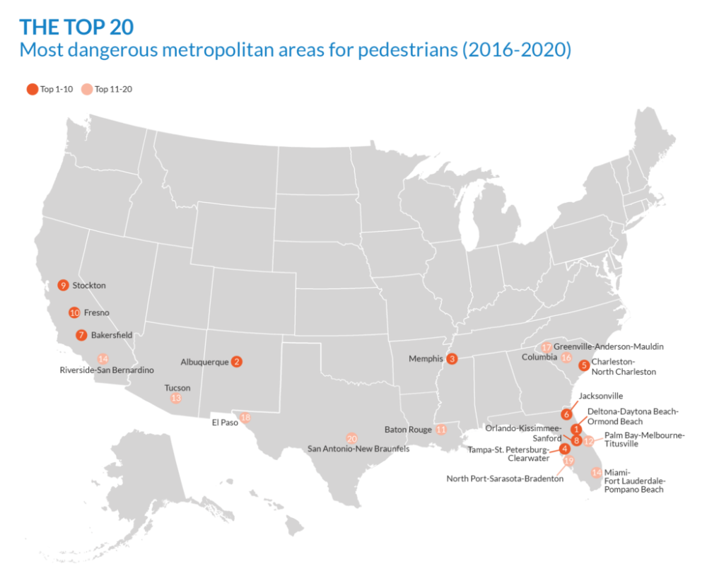
The "Dangerous by Design" report is published periodically by Smart Growth America, a national organization advocating for sustainable development practices. The report analyzes and ranks the pedestrian safety of various metropolitan areas and states based on factors such as pedestrian fatalities, population size, and the percentage of peop le who walk to work. It highlights the challenges and dangers faced by pedestrians in urban and suburban environments, particularly due to inadequate infrastructure, unsafe road design, and a lack of pedestrian-friendly features.
Safe Systems Approach
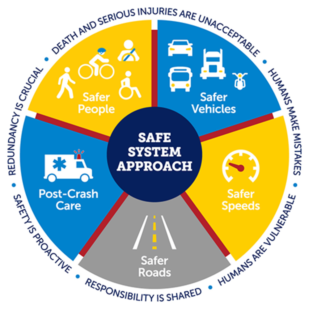
The Safe Systems Approach, U.S. DOT’s guiding paradigm to address roadway safety, is an initiative that promotes the design and operation of road systems with the understanding that humans will make errors. Instead of solely blaming individuals for mistakes, Vision Zero emphasizes creating a forgiving and safe system that can accommodate and mitigate errors without resulting in fatal consequences.
Call to Action
What We are Doing?
Data Analysis and Stakeholder Engagement:
In the pursuit of Vision Zero, data analysis and stakeholder engagement are integral components shaping our comprehensive approach to road safety. Through rigorous data analysis, we gain valuable insights into the factors influencing traffic accidents, identifying high-risk locations, contributing factors, and trends. This analysis informs the development of targeted interventions to enhance safety for all road users, focusing on critical areas such as intersections and crosswalks.
Simultaneously, we recognize the collaborative nature of achieving road safety. Vision Zero emphasizes shared responsibility, involving various stakeholders such as government agencies, road designers, law enforcement, and the community. Our ongoing efforts involve identifying and engaging key stakeholders, including government agencies, law enforcement, community groups, and transportation professionals. By fostering collaboration, we aim to gather local insights, address concerns, and raise awareness about safe road behavior, ultimately contributing to the overarching goal of zero traffic-related fatalities and severe injuries.
How to Get Involved?
JTA Customer Roadway Safety Survey
Thank you for participating in this survey. Your insights as a Jacksonville Transportation Authority (JTA) partner and customer are valuable in helping us understand your perspectives and experiences related to roadway safety and JTA services. This survey is part of our commitment to enhancing safety on our roadways, specifically for JTA services. This is part of our efforts towards Vision Zero – an initiative to eliminate traffic fatalities and severe injuries.
This survey will be open through the end of July 2024.
Please select location on the map where safety improvements are needed?
Please drop a pin on the map where you believe there are safety concerns for pedestrians, bicyclists, transit users, or motorists using the respective pins below. Once the pin has been added to the map, users will have the ability to leave a comment. The map contains existing JTA bus stops ( ) and routes (
 )along with ReadiRide Zones (
 ).
).
Navigating the Map:
To pan the map, click and drag with your mouse in the direction you want to move. You can also use the arrow keys on your keyboard to move the map in small increments. To zoom in and out, you can either use the zoom control buttons on the map interface or scroll with your mouse wheel. You can switch between different map views, such as satellite view or street (map) view, by clicking on the  button on the map interface. To view map in full screen mode select the
  button on the right side of the map. To exit full screen mode, toggle use mouse cursor to the top of the screen and you will see a circle with an X. Click the circle to exit full screen mode.
How to Stay Informed?