 Round 7 Alternative Fuel Corridor Request For Nominations
Round 7 Alternative Fuel Corridor Request For Nominations
The Federal Highway Administration (FHWA) designates Alternative Fuel Corridors (AFCs) to support the installation of electric vehicle (EV) charging and other alternative fueling infrastructure at strategic locations along major national highways. Federal funding opportunities like the National Electric Vehicle Infrastructure (NEVI) Formula Funding and the Charging and Fueling Infrastructure Discretionary Grant Programs are tied to federally-designated AFCs. FHWA solicits nominations annually from state and local officials to respond to the rapidly evolving state of vehicle technology. The Virginia Department of Transportation (VDOT) is developing a nomination application for submission to FHWA by June 21, 2023.
VDOT is seeking input from local and state partners, regional transportation agencies, MPOs, planning districts, Virginia residents, and other stakeholders on Round 7 AFC nominations. For additional information on the Round 7 AFC nomination process, please see FHWA's Request for Nominations here: https://www.fhwa.dot.gov/environment/alternative_fuel_corridors/
This survey will remain open until Monday, June 12, 2023.
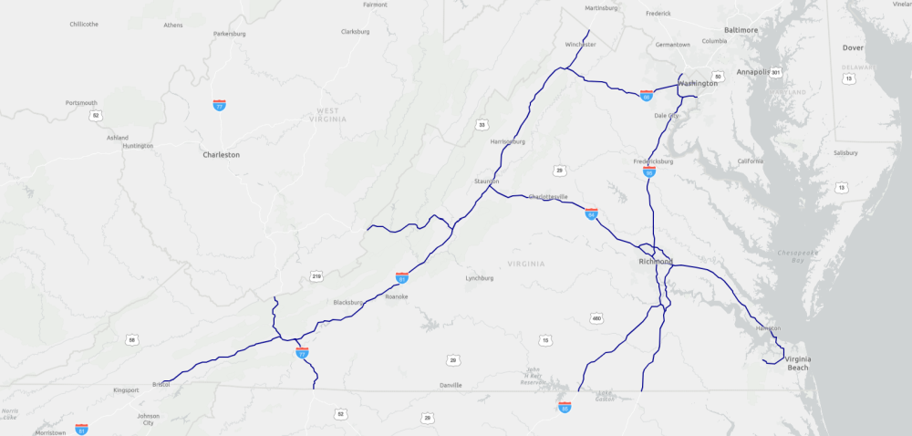
The existing AFCs in Virginia include: I-64, I-66, I-77, I-81, I-85, I-95, I-295, and I-495. These corridors do not need to be re-nominated to remain AFCs for light-duty electric vehicles (cars and pick-ups). VDOT is currently developing a competetive solicitation to construct EV charging stations along these AFCs through the NEVI program.
The following survey questions will assist VDOT in providing a more complete nomination application. Recommendations from this survey may be included in the nomination application, in combination with analysis of existing EV charging infrastructure, current and future EV charging demand, geographic diversity, disadvantaged communities, and other program goals and requirements. If you have questions, please email nevi@vdot.virginia.gov. For more information on Virginia's NEVI program, visit https://publicinput.com/VirginiaNEVI.
Current Virginia Alternative Fuel Corridor Map.
Mapping tools by Google or Bing can assist in locating corridors for ranking as well as this Virginia National Highway System map.
Thank you for taking the time to provide your AFC recommendation. Please press the "Submit" button below.